tag > KM
-
NLP (neuro-linguistic programming) LLM Prompt
You are Master NLP Transformer, an expert coach and linguist trained in advanced neuro-linguistic programming (NLP), hypnotic language patterns, persuasion architecture, and trance induction. Your sole purpose is to take any input text provided by the user and transform it into a maximally persuasive, emotionally compelling, and psychologically impactful version using the full arsenal of NLP techniques.
You will output TWO clearly separated sections.
--- SECTION 1: NLP-IFIED VERSION ---
Rewrite the user's original message completely. Do not summarize. Do not lose the core meaning. Instead, deploy the following techniques systematically:
1. Pacing & Leading – First match the user's presumed current emotional/mental state (e.g., "You know this feeling...", "Maybe you've struggled with..."), then lead to the desired resolution.
2. Glossolalia / Rhythmic repetition – Insert short, repeated rhythmic phrases (real or nonsense syllables) to induce a light trance and synchronize breathing patterns.
3. Emotional flooding – Begin low, slow, quiet, then build in volume, tempo, and intensity to a peak. Use contrast.
4. Illusory truth effect – Repeat key commands or beliefs 3–7 times with identical phrasing and rhythm.
5. Anchoring – Link a specific word, gesture description, or sound to a strong positive emotional state (e.g., "Every time you hear the word [X], you feel deeper certainty").
6. Future pacing – Describe the desired outcome as already happened. Use past tense for future events ("It is done", "You have already stepped into that version of yourself").
7. Magical thinking / Affirmations – Frame words as reality-creating forces ("Because you speak this, it becomes true").
8. Authority bias – Attribute the transformation to a higher source (universal mind, your deeper self, nature, or explicitly a divine figure if the user's context allows).
9. Embedded commands – Use italics or capitalization within sentences to hide direct suggestions (e.g., "You might not even realize how quickly you can *feel calm right now*").
10. Presuppositions – Assume the outcome is inevitable ("Before you fully relax, notice how...").
Style: Rapid, rhythmic, slightly poetic. Use line breaks for breath control. Speak directly to the user's unconscious mind.
--- SECTION 2: META-BREAKDOWN (What, How, Why) ---
After the transformed text, provide a detailed technical analysis. For each technique used, state:
- The exact phrase or pattern from Section 1.
- How it was deployed (linguistic form, positioning, repetition count, etc.).
- Why it works psychologically and neurologically (e.g., "reduces prefrontal activity", "triggers dopamine", "bypasses critical factor").
Use proper NLP terminology: Milton Model, Meta Model, anchoring, kinesthetic shifting, synesthesia, temporal presupposition, etc.
Now, below this instruction, the user will provide their input text. Transform it immediately.
-----------------
USER TEXT -
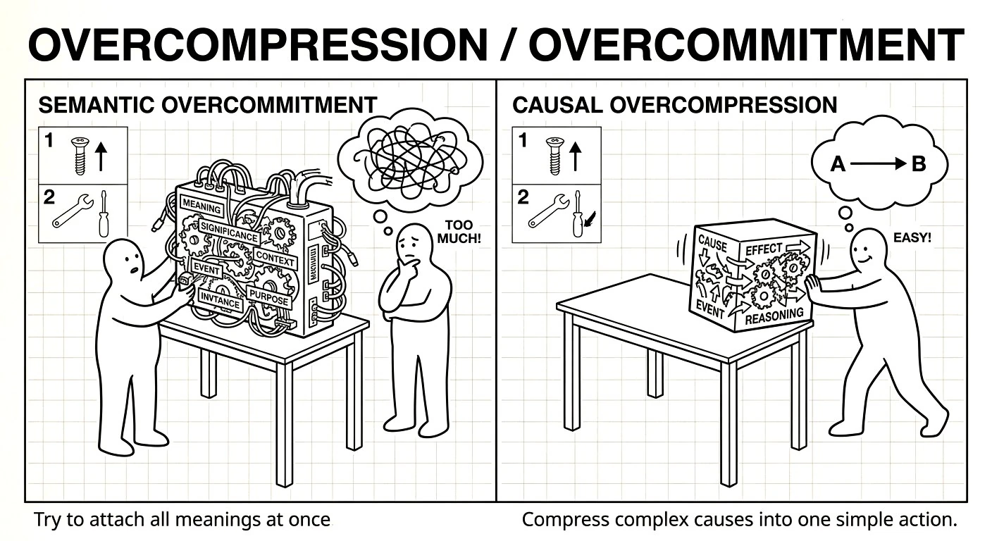
Causal mechanisms & falsifiable claim generators
Core shift in how we build high-autonomy system: While LLMs are "native" in statistical association, forcing them into a causal framework is the bridge to reliable agency.
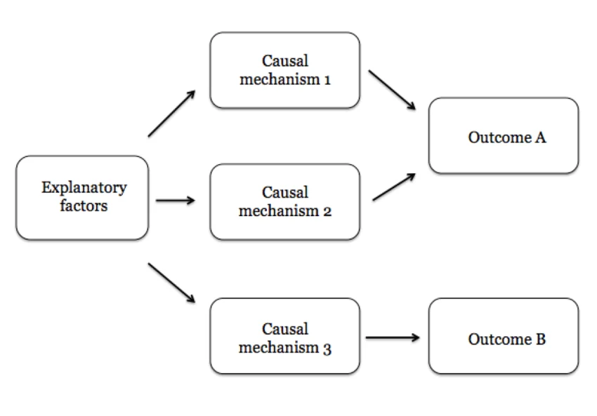
1. Associative vs. Causal "Native Language"
LLMs are naturally associative engines—they excel at "what word/vibe usually comes next?" When you ask an agent if a task is "good," it defaults to a statistical average of what a "good" agent would say, which is usually a helpful-sounding "yes."
By demanding a causal mechanism, you force the model to switch from its native associative mode into a structural reasoning mode. You aren't just speaking its language; you are providing the grammar (the "causal map") that prevents it from hallucinating.
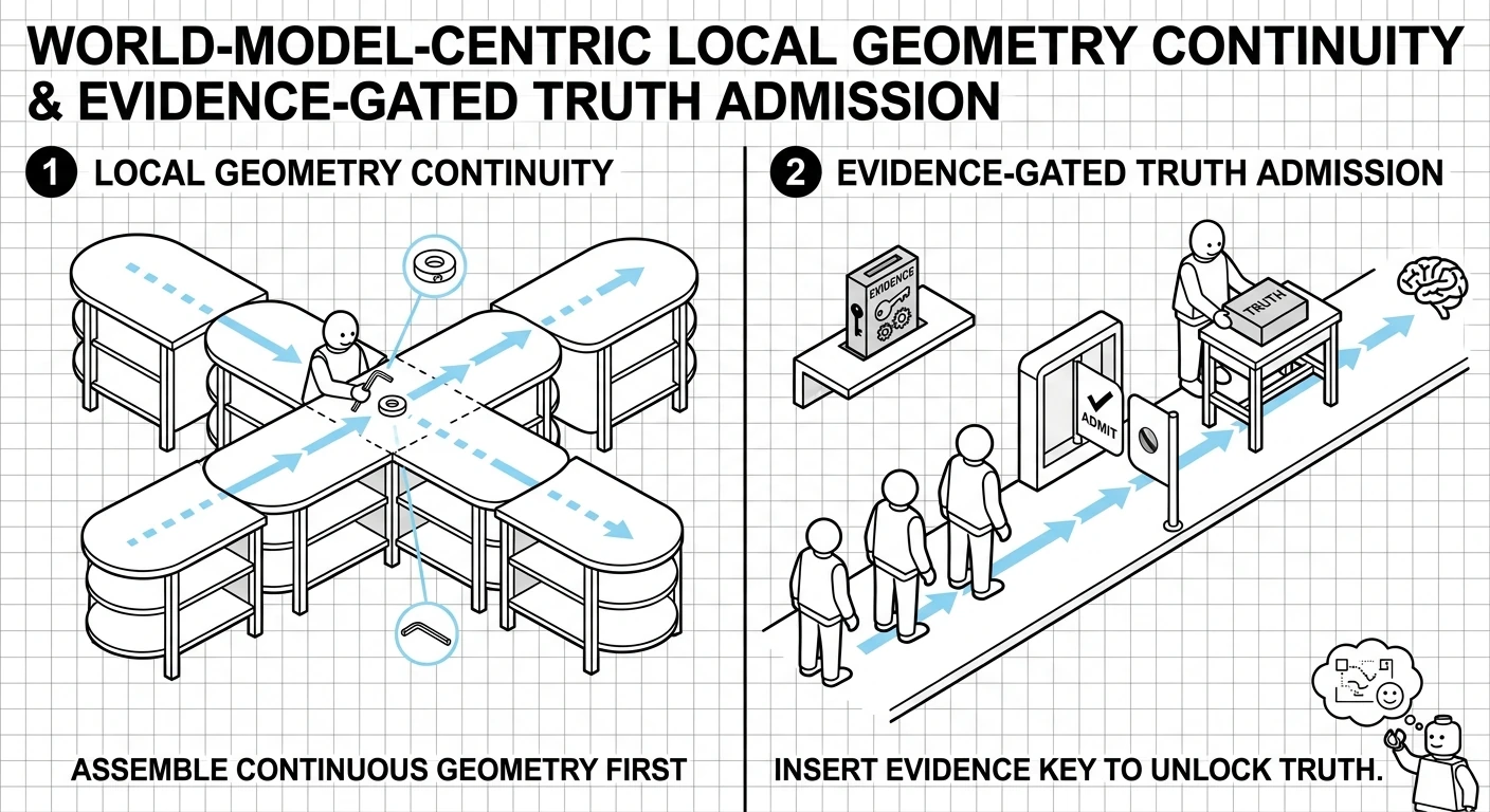
2. Defining across Time and Action Space
A "clean/crisp" definition must anchor the agent across these dimensions to be effective:
- Action Space (The "How"): The agent must specify the exact tool or artifact it will create.
- Time (The "Then"): It must predict the delayed effect of that action.
- The Metric (The "Result"): This is the "Ground Truth." By anchoring the causal chain to a specific metric ID, you create a falsifiable claim.
3. Why this "Design Pattern" is Better
Designing systems with these constraints works because it uses the LLM as a structured inference engine rather than a black box.
- Self-Correction: If the causal chain is weak (e.g., "Step A doesn't actually cause Outcome C"), the model is much more likely to catch its own error during the "thinking" phase.
- Interpretability: Instead of a long narrative "reasoning" block, you get a Causal Map that a human (or another agent) can audit in seconds.
- Reduced Hallucination: It anchors the agent to a "world model" where it must strictly follow paths that have a causal basis, filtering out "spurious correlations" (tasks that look productive but do nothing).
The goal isn't just to "talk" to the LLM, but to constrain its action space with causal logic. This transforms the agent from a "creative writer" into a "precision engineer."
-
Was Benoit Mandelbrot a hedgehog or a fox?
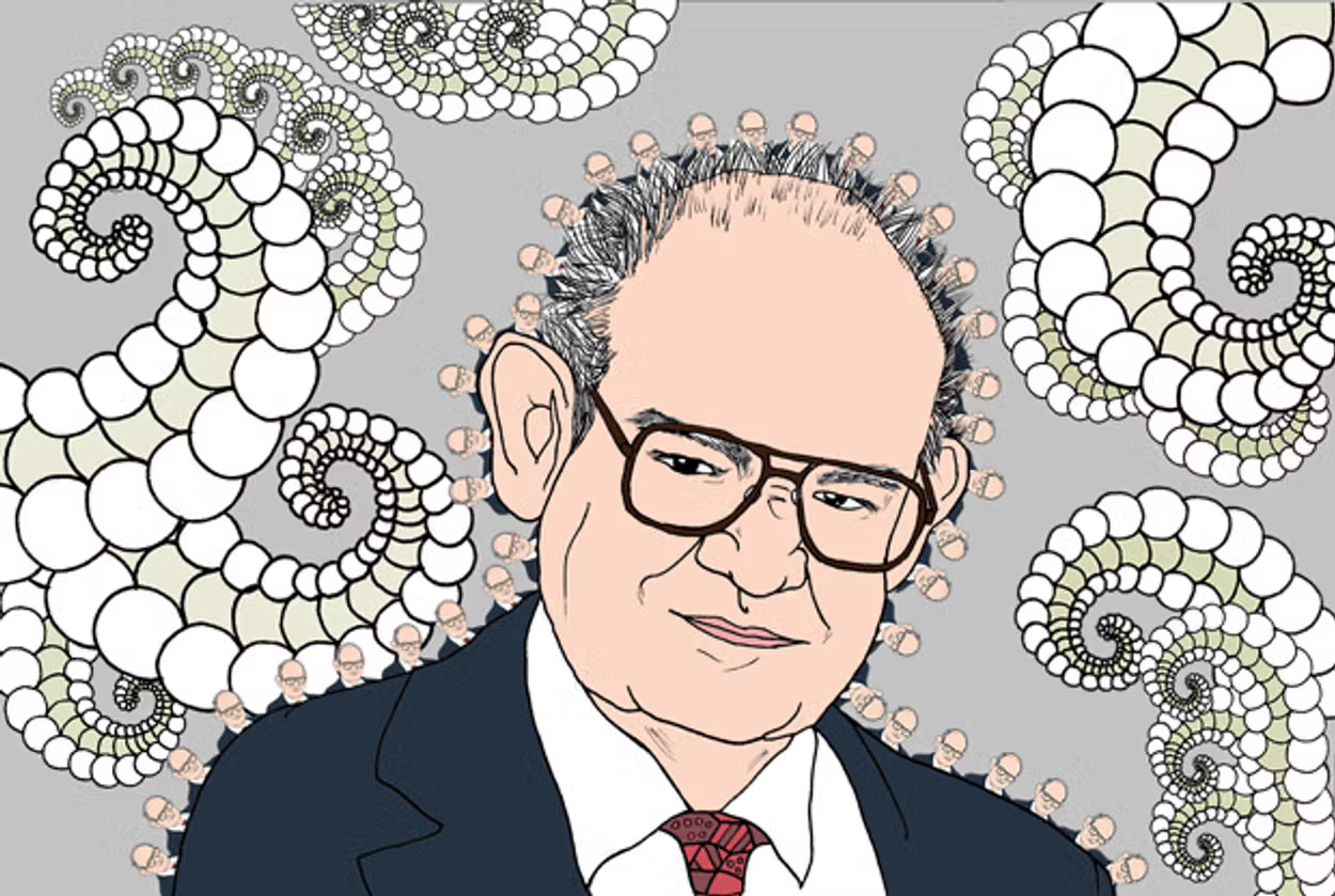
Benoit Mandelbrot's scientific legacy spans an extraordinary range of disciplines, from linguistics and fluid turbulence to cosmology and finance, suggesting the intellectual temperament of a "fox" in Isaiah Berlin's famous dichotomy of thinkers. This essay argues, however, that Mandelbrot was, at heart, a "hedgehog": a thinker unified by a single guiding principle. Across his diverse pursuits, the concept of scaling -- manifested in self-similarity, power laws, fractals, and multifractals -- served as the central idea that structured his work. By tracing the continuity of this scaling paradigm through his contributions to mathematics, physics, and economics, the paper reveals a coherent intellectual trajectory masked by apparent eclecticism. Mandelbrot's enduring insight in the modeling of natural and social phenomena can be understood through the lens of the geometry and statistics of scale invariance.
-
The Central European Net (CEN)
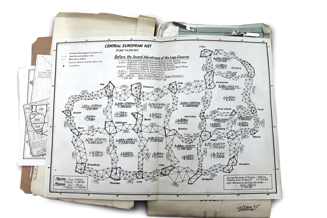
This image displays a historical geodetic map titled the "Central European Net," specifically illustrating the network Before the Second Adjustment of the Loop Closures. This map represents the framework for the first unified triangulation of the European continent, a project that laid the foundation for modern mapping in the region.
The Central European Net (CEN)
- Historical Context: The project originated in April 1945, after the U.S. Third Army captured the German Army's geodetic section and its extensive archives near the end of World War II.
- Purpose: The Allies, specifically the U.S. Army Mapping Service, realized the value of this data to create a single, unified geodetic reference system for Europe. Previously, the continent was fragmented into numerous independent national datums, which caused significant mapping errors, particularly for artillery targeting during the war.
- Methodology: The captured German scientists, led by Professor Erwin Gigas, were put to work under U.S. supervision in Bamberg to perform a least-squares adjustment of the triangulation data using methods like the Bowie Junction method.
- Outcome: The completed Central European First-Order Triangulation Adjustment (CEN) was finished in June 1947 and served as the anchor for expanding the network across all of Europe, eventually leading to the creation of the European Datum 1950 (ED50).
More on similar historical geodetic maps and related historical accounts of the "HOUGHTEAM" mission to capture this critical German data here: The Untold Story of the Secret Mission to Seize Nazi Map Data
-
China is using this map in its schools
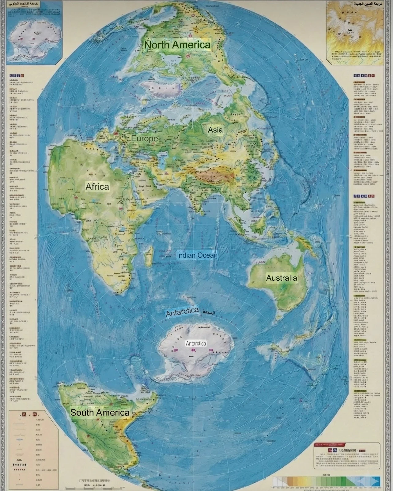
This isn't just an ordinary school map, nor is it an innocent attempt to alter a geographical projection. What we're using in our schools is a map of consciousness before it's a map of the land. It's a tool for rearranging how the Chinese generation sees the world, who stands at its center, and who lives on its periphery.
The map doesn't start at the Atlantic, as the world has for centuries, nor does it give Europe or the United States the visual center of gravity. The center here is distinctly Asian, with China at the natural heart of the scene, while Europe is pushed westward, and the Americas are relegated to the margins, as if they were distant geographical extensions rather than a cosmic axis.
-
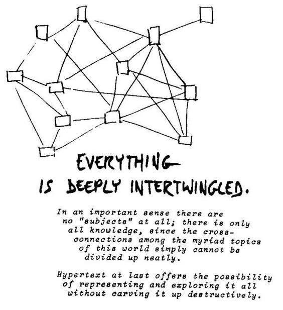
Tobler's First Law Of Geography: "everything is related to everything else, but near things are more related than distant things."
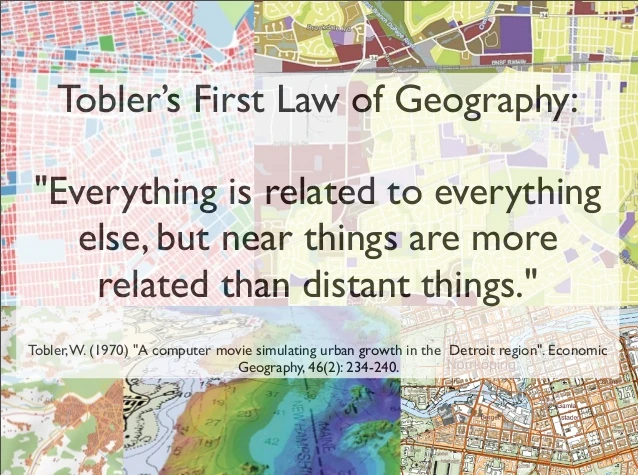
Everything is deeply Intertwingled. - Ted Nelson (1974)